Monday, August 10, 2009

Wrangel Island, Russia


Russia-25, originally uploaded by Abhishek's Received Postcards.

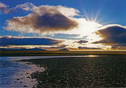
Wrangel Island is an island in the Arctic Ocean, between the Chukchi Sea and East Siberian Sea. Wrangel Island lies astride the 180° meridian. The International Date Line is displaced eastwards at this latitude to avoid the island as well as the Chukchi Peninsula on the Russian mainland. The closest land to Wrangel Island is tiny and rocky Herald Island located 60 km (37 mi) to the east.
Wrangel Island belongs administratively to the Chukotka Autonomous Okrug of the Russian Federation. This rocky island has a weather station and two permanent Chukchi fishing settlements on the southern side of the island
Read more...

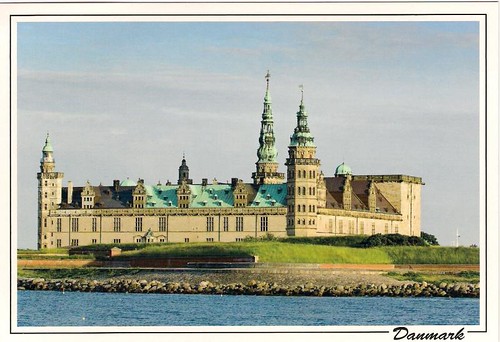
Kronborg Castle, Helsingor, Denmark


Denmark-2, originally uploaded by Abhishek's Received Postcards.

Kronborg is situated near the town of Helsingør (immortalised as Elsinore in Shakespeare's Hamlet) on the extreme northeastern tip of Zealand at the narrowest point of the Øresund, the sound between Denmark and Sweden. In this part, the sound is only 4 km wide, hence the strategic importance of maintaining a fortress at this location commanding one of the few outlets of the Baltic Sea. The castle has for centuries been one of the most important Renaissance castles in Northern Europe and was added to UNESCO's World Heritage Sites list on November 30, 2000.

Read more...

Fort William, Scotland, United Kingdom

Fort William (Scottish Gaelic: An Gearasdan, "The Garrison") is the largest town in the highlands of Scotland and second largest settlement behind the city of Inverness.
Fort William is a major tourist centre with Glen Coe just to the south, and Glenfinnan to the west, on the Road to the Isles. It is an important centre for hillwalking and climbing due to its proximity to Ben Nevis and many other Munro mountains, marketing itself as the "Outdoor Capital of the UK". It is also well known for its nearby famous Downhill Mountain Bike Track and its connection to the West Highland Way from Glasgow and the Great Glen Way; a walk/cycle way from Inverness to Fort William through the Great Glen.

Read more...

Cascata delle Marmore, Italy


Italy-40, originally uploaded by Abhishek's Received Postcards.

The Cascata delle Marmore (Marmore's Falls) is a man-made waterfall created by the ancient Romans. Its total height is 165 m (541 feet), making it one of the tallest in Europe and the tallest man-made waterfall in the world. Of its 3 sections, the top one is the tallest, at 83 m (272 feet).
It is located 7.7 km from Terni, a provincial capital of the Italian region of Umbria.

Read more...

Swedish Lappland. Skäckerfjällen, Jämtland, Sweden


Sweden-8, originally uploaded by Abhishek's Received Postcards.

The Laponian area is a large mountainous wildlife area in the Lapland province in northern Sweden, more precisely in the Gällivare Municipality, Arjeplog Municipality and Jokkmokk Municipality. It was made a UNESCO World Heritage Site in 1996.
The total area is about 9400 km², making it the world's largest unmodified nature area which is cultured by natives -- the natives in this case being the reindeer herding Sami people also known as laps. Being so large, the geography of the area varies greatly. Each nature reserve and national park has its distinctive features.
95% of the area is protected as national parks or nature reserves. It consists of the national parks Muddus, Sarek, Padjelanta and Stora Sjöfallet, and the nature reserves Sjaunja and Stubba. The other 5% are in the areas of Sulitelma, Tjuoltadalen, and Rapadalen. The village Porjus is a natural port to the Laponian area and has recently opened an information center.

Read more...

Stora Alvaret, Sweden


Sweden-7, originally uploaded by Abhishek's Received Postcards.

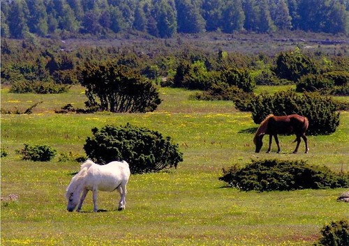
The Stora Alvaret is a limestone barren plain on the island of Öland, Sweden. Because of the thin soil mantle and high pH levels, a great assortment of vegetation is found including numerous rare species. Stora Alvaret has been designated as a World Heritage Site by UNESCO due to its extraordinary biodiversity and prehistory. The area of this formation exceeds 260 km², making it the largest such expanse in Europe and comprising over one fourth of the land area of the island. Stora Alvaret is not devoid of trees, contrary to a common misconception; in fact, it holds a variety of sparse stunted trees akin to a pygmy forest. The Stora Alvaret, sometimes called the Great Alvar, is a dagger shaped expanse almost 40 kilometers long and about 10 kilometers at the widest north end.

Read more...

Dinosaur Provincial Park, Canada


Canada-8, originally uploaded by Abhishek's Received Postcards.

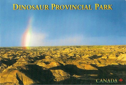
Dinosaur Provincial Park is a World Heritage Site located about two and a half hours drive southeast of Calgary, Alberta, Canada or 48 kilometers (30 mi) northeast of Brooks.
The park is situated in the valley of the Red Deer River, which is noted for its striking badland topography. The park is well known for being one of the greatest dinosaur fossil beds in the world. Thirty-nine dinosaur species have been discovered at the park and more than 500 specimens have been removed and exhibited in museums across the globe. Its significance justified it becoming a World Heritage Site in 1979.

Read more...

Old Rauma, Finland


Finland-17, originally uploaded by Abhishek's Received Postcards.

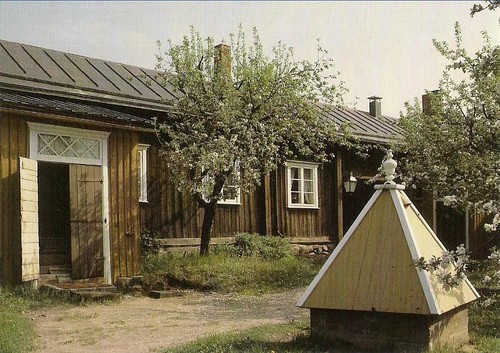
Old Rauma is the wooden city centre of the town of Rauma, Finland. It is listed as a Unesco world heritage site.

The area of Old Rauma is about 0.3 km², with approximately six hundred buildings (counting both proper houses and smaller buildings like sheds) and about 800 people living in the area. The town of Rauma expanded outside the Old Rauma proper only in the early 1800s. The oldest buildings date from the 18th century, as two fires of 1640 and 1682 destroyed the town. Most buildings are currently inhabited and owned by private individuals, although along the two main streets and around the town square they are mainly in business use.
Locations of special interest include the Kirsti house, which is a seaman's house from the 18th and 19th centuries, and the Marela house, which is a shipowner's house dating to the 18th century but with a 19th century facade, both of which are currently museums. Other sights include the rare stone buildings of the Old Rauma: the Church of the Holy Cross, an old Franciscan monastery church from the 15th century with medieval paintings and the old town hall from 1776. Another church in Rauma, the Church of the Holy Trinity, also from the 15th century, burned in the fire of 1640.

Read more...

Sunday, August 9, 2009

Ghost Walkers, Namibia


Namibia-1, originally uploaded by Abhishek's Received Postcards.

Elephants leaving a waterhole noiselessly at sunset at Etosha.

Etosha National Park is a national park in the Kunene Region of northwestern Namibia. The park shares boundaries with the regions of Oshana, Oshikoto and Otjozondjupa.

Read more...

Bahá’i Holy Places in Haifa, Israel


Israel-4, originally uploaded by Abhishek's Received Postcards.

The Bahá'í World Centre buildings are buildings that are part of the Bahá'í World Centre in Israel. The Bahá'í World Centre buildings include both the Bahá'í holy places used for pilgrimage and the international administrative bodies of the Bahá'í Faith; they comprise more than 20 different administrative offices, pilgrim buildings, libraries, archives, historical residences, and shrines. These structures are all set amidst more than 30 different gardens or individual terraces.
The buildings themselves are located in Haifa, Acre, and Bahjí, Israel. The location of the Bahá'í World Centre buildings has its roots to Bahá'u'lláh's imprisonment in Acre, which is near Haifa, by the Ottoman Empire during the Ottoman Empire's rule over Palestine, now Israel.

Read more...