Saturday, December 5, 2009

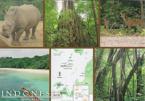
Sangiran Early Man Site, Indonesia

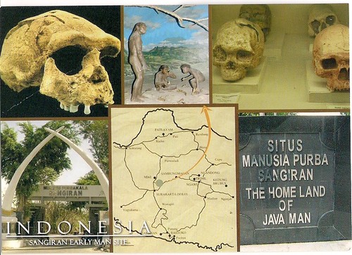
Sangiran is an archaeological excavation site at the island of Java in Indonesia. The area comprises about 48 km² and is located in Central Java, about 15 kilometers north of Surakarta in the Solo River valley. In 1996 it was accepted as World Heritage by the UNESCO.
In 1934 the anthropologist Gustav Heinrich Ralph von Koenigswald started to examine the area. During excavations in the next years fossils of some of the first known human ancestors, Pithecanthropus erectus ("Java Man", now reclassified as part of the species Homo erectus), were found here. About 60 more human fossils, among them the enigmatic "Meganthropus", have since been found here. In addition, there are considerable numbers of remains of the animals that these primitive humans hunted, and of others that merely shared the habitat.

Read more...

Ujung Kulon National Park, Indonesia

Ujung Kulon National Park is located at the western-most tip of Java, Indonesia. It includes the volcanic island group of Krakatoa and other islands including Panaitan, Handeuleum and Peucang. The park encompasses an area of 1,206 km² (443 km² marine), most of which lies on a peninsula reaching into the Indian Ocean. The explosion of nearby Krakatau in 1883 produced a tidal wave that eliminated the villages and crops of the coastal areas on the western peninsula, and covered the entire area in a layer of ash about 30 cm thick. This caused the total evacuation of the peninsula by humans, thereby allowing it to become a repository for much of Java’s flora and fauna, and most of the remaining lowland forest on the island.
It is Indonesia's first national park and was declared a UNESCO World Heritage Site in 1992 for containing the largest remaining lowland rainforest in Java. It is also one of only two homes of the critically endangered Javan Rhinoceros.

Read more...

Lorentz National Park, Indonesia

Lorentz National Park is located in the Indonesian province of Papua, formerly known as Irian Jaya (western New Guinea). With an area of 25,056 km² (9,674 mi²), it is the largest national park in South-East Asia. In 1999 Lorentz was declared a World Heritage Site by UNESCO.
An outstanding example of the biodiversity of New Guinea, Lorentz is one of the most ecologically diverse national parks in the world. It is the only nature reserve in the Asia-Pacific region to contain a full altitudial array of ecosystems spanning from marine areas, mangrove, tidal and freshwater swamp forest, lowland and montane rainforest, alpine areas, and equatorial glaciers. At 4884 meters, Puncak Jaya (formerly Carstensz Pyramid) is the tallest mountain between the Himalayas and the Andes.

Read more...

National Maritime Museum, United Kingdom

The National Maritime Museum (NMM) in Greenwich, England is the leading maritime museum of the United Kingdom and may be the largest museum of its kind in the world. The historic buildings forming part of the Maritime Greenwich World Heritage Site, it also incorporates the Royal Observatory, Greenwich, and 17th-century Queen's House. The museum is a non-departmental public body sponsored by the Department for Culture, Media and Sport.
The museum was officially established in 1934 within the 200 acres (0.81 km2) of Greenwich Royal Park in the buildings of what was the former Royal Hospital School (or Royal Naval School). It includes the Queen's House (part of the historic park-and-palace landscape of "Maritime Greenwich", which was inscribed as a UNESCO World Heritage Site in 1997) and the Royal Observatory, Greenwich, until 1948 the home of the Royal Greenwich Observatory.

Read more...

Royal Botanic Gardens, Kew, United Kingdom

The Royal Botanic Gardens, Kew, usually referred to simply as Kew Gardens, are 121 hectares of gardens and botanical glasshouses between Richmond and Kew in southwest London, England. The Royal Botanic Gardens, Kew is also the name of the organisation that runs Kew Gardens and Wakehurst Place gardens in Sussex. It is an internationally important botanical research and education institution. The gardens are a non-departmental public body sponsored by the Department for Environment, Food and Rural Affairs. Created in 1759, the gardens celebrated their 250th anniversary in 2009.
In July 2003, the gardens were put on the list of World Heritage Sites by UNESCO.

Read more...

Seine, France


France-13, originally uploaded by Abhishek's Received Postcards.

The Seine is a slow-flowing major river and commercial waterway within the regions of Île-de-France and Haute-Normandie in France and famous as a romantic backdrop in photographs of Paris, France. It is also a tourist attraction, with excursion boats offering sightseeing tours of the Rive Droite and Rive Gauche within the city of Paris. It terminates in the Bay of the Seine region of the English Channel and is navigable by ocean-going vessels for about ten percent of its length, as far as Rouen, 120 km (75 miles) from the sea, while over sixty percent of its length, as far as Burgundy near the Swiss Alps, is negotiable by commercial riverboats and nearly its whole length is available for recreational boating.

In 1991, the banks of the Seine in Paris—the Rive Gauche and Rive Droite—were added to UNESCO's list of World Heritage Sites in Europe.

Read more...

Friday, December 4, 2009

Saalburg, Upper Germanic Limes/Frontiers of the Roman Empire, Germany


Germany-44, originally uploaded by Abhishek's Received Postcards.


The Limes Germanicus (Latin for Germanic frontier) was a remarkable line of frontier (limes) forts that bounded the ancient Roman provinces of Germania Inferior, Germania Superior and Raetia, and divided the Roman Empire and the unsubdued Germanic tribes, from the years 83 to 260. At its height, the limes stretched from the North Sea outlet of the Rhine to near Regensburg on the Danube.
The Limes Germanicus was divided into:
The Lower Germanic Limes, which extended from the North Sea at Katwijk in the Netherlands along the then main Lower Rhine branches (modern Oude Rijn, Leidse Rijn, Kromme Rijn, Nederrijn)
The Upper Germanic Limes started from the Rhine at Rheinbrohl (Neuwied (district)) across the Taunus mountains to the river Main (East of Hanau), then along the Main to Miltenberg, and from Osterburken (Neckar-Odenwald-Kreis) south to Lorch (Ostalbkreis) in a nearly perfect straight line of more than 70 km;
The proper Rhaetian Limes extended east from Lorch to Eining (close to Kelheim) on the Danube.
Roman border defences have become much better known through systematic excavations financed by Germany and through other research connected to them. In 2005, the remnants of the Upper Germanic & Rhaetian Limes were inscribed on the List of UNESCO World Heritage Sites as Frontiers of the Roman Empire. The Saalburg is a reconstructed fortification and museum of the Limes near Frankfurt.

Read more...